Outcrop design
Donegal County 3d map medium
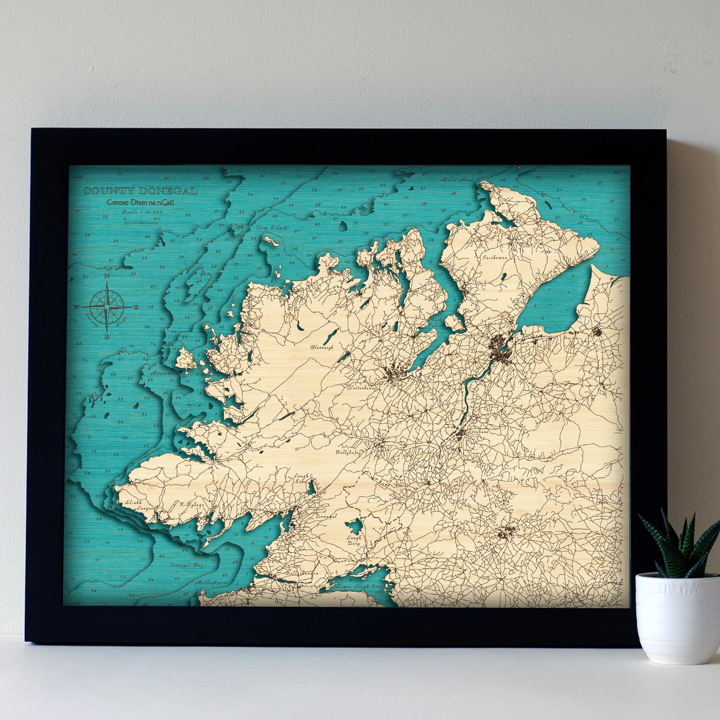
COUNTY DONEGAL, IRELAND
Dún na nGall
Medium Size 3d Art Maps
County Donegal, perched on Ireland’s rugged northwest coast, is famed for its dramatic cliffs, golden beaches, and untamed Atlantic beauty. Home to the towering Slieve League sea cliffs—among the highest in Europe—and the windswept Wild Atlantic Way, it’s a place of deep history and raw natural charm. From traditional fishing villages to Gaelic-speaking communities, Donegal offers a powerful sense of place and timeless connection to the land and sea.
Areas Covered
- Donegal Bay
- Mullaghmore
- Lower Lough Erne
- Ballyshannon
- Sliabh League
- Killybegs
- Lough Derg
- Ballybofey
- Strabane
- Derry
- Arranmore
- Glenveigh
- Letterkenny
- Tory Island
- Inishowen
- Malin Head
Roads shown in full detail.
Choose options
Accurate:
We meticulously combine international and local survey data, satellite imagery, and historical maps to design each Outcrop art map from scratch with precision and accuracy.
Detailed:
Using cutting-edge laser technology, we capture the finest details of Ireland’s landscapes and coastlines, bringing every contour and feature to life.
Innovative Round Frames:
Our unique patent-pending round frames, crafted from FSC-certified birch sourced from sustainably managed Finnish forests, are a seamless blend of minimalist design and eco-conscious materials, adding a contemporary touch to any space.
Exceptional Quality:
Every piece is hand-finished using traditional techniques, ensuring your artwork meets the highest standards of craftsmanship and is built to last.
Designed and Made in Sligo, Ireland:
Proudly handcrafted in our Sligo workshop, each map reflects the spirit of Irish design, sustainability, and local artistry.
Sustainably Sourced Wood:
Each layer of our map is crafted from FSC-certified bamboo plywood, known for its strength, beauty, and eco-friendly credentials.
Eco-Friendly Finishes:
We use water-based, non-toxic glues and stains that enhance the natural character of the wood in the most eco-friendly way possible
Innovative Round Frames:
Our new round frames are made from FSC-certified birch, carefully sourced from sustainably managed Finnish forests, reflecting our commitment to responsible materials and exceptional design.
Thoughtful Packaging:
Every artwork is wrapped in protective tissue and presented in an unbleached, recycled cardboard box, ensuring it arrives safely and sustainably to its new owner.
Every map comes in its own recycled cardboard presentation box, framed and ready to hang. We include an elegant clip together stand to allow your map to stand upright on a shelf or table. We do not use glass in any of our maps so you can better appreciate the depth and tactile nature of the artwork.
- Outside frame diameter 220mm, 42mm deep
- 4 layers of 3mm thick bamboo
- Approx 500gm for easy postage
- Ready to hang or stand
- Birch frame with either black or natural inner
- All depths shown are in metres